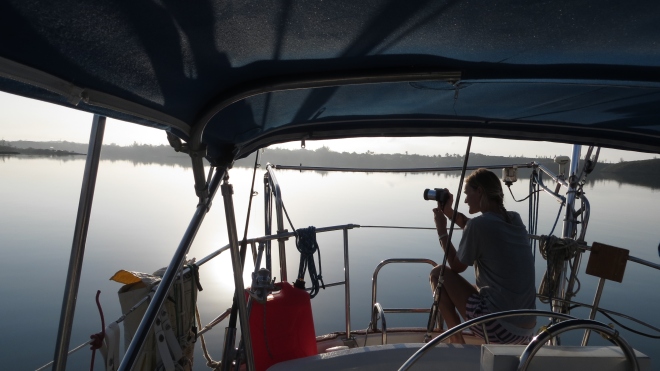
It’s 8pm, the moon has risen and the stars are shining brightly in the sky. Ben’s stood at the bow of the boat discovering the underwater world by the light of his torch. It’s the night before we make the crossing from the Abacos to Eleuthera. We need an early night as we’re due to be up before sunrise to commence the 11 hour crossing. Unfortunately mother nature has a different idea and puts us in a bit of a sticky situation resulting in panic and a sleepless night… but I’ll tell you all about that another time.
The following day we leave Channel Cay in the Abacos in darkness to start the 60 nautical mile journey. As we make our way through the deeper waters of the North East Providence Channel we have the sun rising to our port side, and the moon setting to starboard. We have good weather conditions and reasonably calm seas….just how we like it! The wind is coming from a perfect angle so we hoist the sails and sail the whole way to our destination, Royal Island, Eleuthera.

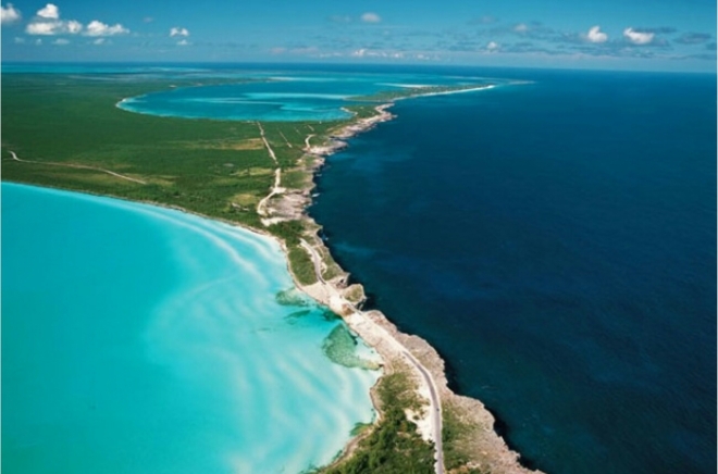
Royal Island
The island itself is private but it centres around a natural harbour providing protection from winds from almost all angles. We pick a suitable spot and anchor for the evening. After anchoring we see a young couple from another yacht coming over to say hi, it’s the same yacht that had a bump in the night during a storm back at Green Turtle. We welcome them aboard for a quick catch up, we’d love to be feeling more sociable but after a sleepless night last night and a long journey today we both are in dire need of dinner and our bed.
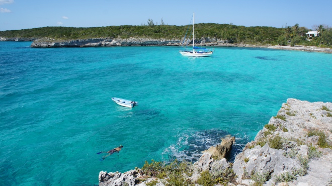
We spend a couple of days around the Royal Island area exploring some old ruins and snorkelling a shipwreck. The Arimoroa was a Lebanese steel freighter carrying fertiliser that caught fire and was intentionally run aground in order to save the crew. Fifty seven years on and the 260 foot remains have made a fantastic home for thousands of fish, varying from small colourful wrasse to large barracuda and many others in between. The bulk of the wreck sits 25 feet below the surface of the water, as we snorkel we look down onto the fish darting in and out of the steel panels, pipes and crevices.
At one end a large part of the freighter juts up and out of the water, breaking the surface at low tide. It has the effect of a tower but it appears this was possibly the stern of the vessel. The side facing the rest of the wreckage has the remains of brackets and panels allowing fish to hide within. As we swim around the other side of the imposing structure it smoothly drops away, like a wall, straight down to the seabed. On the almost vertical surface coral has grown providing a colourful display and two silver barracudas are patrolling the waters in search of their next meal. We follow suit and grab our spears from the dinghy. We successfully catch dinner and promptly get the fish out of the water and into the dinghy to prevent a hungry barracuda stealing our catch. As we continue to swim around we spot a large fish lurking around the wreck around 20 feet below us. It appears to be 3-4 feet in length with a rounded, dark body. We don’t know what kind of fish it is but going by its size and evil looking face we don’t want to get too close.
After an hour in the water I get a little chilly so venture back into the dinghy where I sunbathe to warm up. Ben remains in the water and every now and again pops back to the dinghy with another fish protruding from the water on the end of the spear. The sun is warm today and there’s a gentle breeze. Laying on the dinghys seat, slowly bobbing around with the waves is nice and relaxing, that is until I’m splashed with water from one of our catch flapping around in the hull.
I look up to see Ben swimming fast towards me, his spear isn’t out the water so he hasn’t caught a fish. A quick signal by him of his flat hand raised upright against his forehead tells me there’s a shark in there with him. I jump up and help him into the safety of the dinghy and we head back to our yacht.

Over the next couple of weeks we sail between anchorages in the Eleuthera area, exploring different destinations as we go.
At Spanish Wells we pick up one of the few moorings available, it’s a pretty tight spot but I successfully manoeuvre our yacht and Ben picks up the mooring with a boat hook on our first attempt. Spanish Wells is a traditional Bahamian fishing town and we’re amongst the hub of activity. We watch large fishing vessels come and go through the dredged channel. The docks are lined with more vessels and workers ready to help bring in the days catch. The vessels are so large and the channel so narrow, an announcement is made over the VHF for each departure and arrival so other mariners stay out of the way. It’s not the most picturesque of places here but it’s interesting to see the world go by.

We like that the town’s not aimed at tourists and I would imagine the majority of their visitors are cruisers. There are a few facilities here we require including a supermarket and a hardware store. After wandering around for a few hours we discover a locals bar that serves food and drink at good prices so we treat ourselves to lunch out. As we’re walking back my feet are aching and I’m suffering from a bit of a food coma, I think to myself it’d be great if someone passing were to stop and give us a lift. Within 30 seconds of this thought passing through my mind a lady driving a golf cart pulled up next to us and offered us just that! We whizz along and within minutes we’re back at our dinghy, my feet have never been so thankful.
As we continue with our sailing journey we pass between the islands of Current Cay and Eleuthera. It’s a tricky stretch of water to navigate through, known as Current Cut. As the tide rises and falls water rushes through this 300 foot wide channel at up to 10 knots…bearing in mind our average cruising speed is 5-6 knots, that’s a fast current to contend with. We have timed our arrival for slack tide; when the tide is turning the current is less powerful and it makes for a safer journey through. We arrive at the western side of the cut bang on schedule at 07.53 hrs, but it seems the tidal times are slightly inaccurate and in fact the tide is still rising. As we enter towards the cut I keep the engine revs continuous and monitor our speed over the ground in order to gauge the flow of water; 4 knots, 4.5, 5, 5.5….we’re being sucked in by the current. In order to have steerage I have to be going faster than the flow of water so I crank up the engine. Ben’s up on deck watching the flow of water carefully whilst I keep the boat in control. My eyes flick up and down between the water ahead and down to the electronic GPS chart in front of me. Our charts show a recommended route through the cut which I try to keep to. The angle of the flow of water changes and I have to turn the wheel quite substantially at times to keep us on track. On either side of us is shallow water so there’s not much room for error. The surface of the water surrounding us is rippling and the current is clearly visible. I check our speed, 10 knots! We’re flying through. The current is so strong at one stage I come slightly off track but manage to correct it. As we near the other side of the cut I feel the flow of water weaken slightly and know we’re nearly there. We’re spat out by the current onto the eastern side of the cut where, after contending with a few waves caused by the wind going against the tide, we turn north towards the Glass Window Bridge.
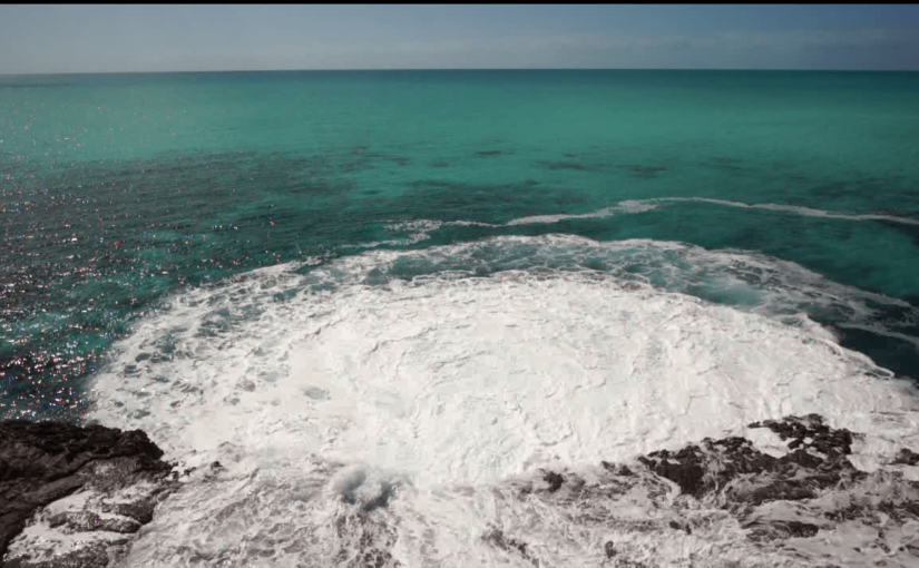
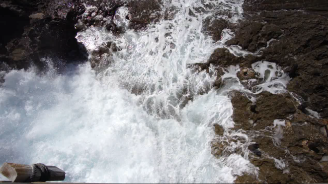
Glass Window Bridge
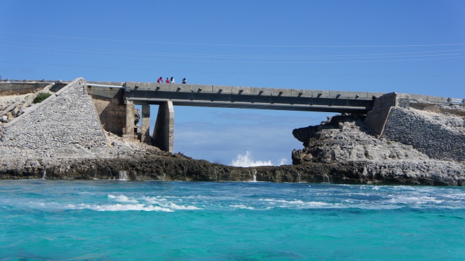
If you’ve ever wondered what happens when water hits land for the first time in 3600 miles, this is one of the best places to get your answer. At Eleuthera’s narrowest point a bridge connects one half the island with the other in a dramatic setting showing the full force of mother nature. Stood on the bridge looking north the deep dark blue waters of the North Atlantic are visible way off into the distance. Looking south you are greeted by views of shallow turquoise waters. Looking straight down below the bridge however is a noisy, dangerous chaos. In the last 9 miles of the North Atlantic water’s journey the seabed goes from 16800 feet deep, to nothing. As a result the vast volume of water suddenly has no where to go and huge waves crash into the cliff faces along this stretch of land. Where the bridge lays however there is nothing stopping the almighty waves. As the water reaches the land it funnels in between the rock faces on either side of the bridge and crashes through underneath where it then floods into the turquoise waters on the other side. We’re here in reasonably good weather and the power of this event is still phenomenal. In bad weather the waves are known to hit 100 feet high resulting in people losing their lives and even causing the bridge to be wiped out entirely.


Gregory Town, Hatchet Bay, Alice Town
Further along the Southern coast of Eleuthera we explore the small villages of Gregory Town and Alice Town/Hatchet Bay. We use the launderette at Gregory Town to catch up with some washing but unfortunately the washing comes out dirtier than when it went in. So if you’re a cruiser reading this, we recommend you use the launderette on the outskirts of Alice Town instead…unless of course you like having brown stains on your outfits.

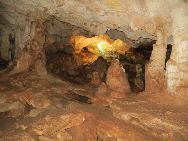
At Alice Town we dig out the foldable bikes, pop them in the dinghy and go ashore. We cycle a few miles out of town to some caves and then on further to surfers beach where we have a pit stop. Sitting on the sand we devour our picnic whilst watching the surfers conquer the waves rolling in.


Rock sound
From Hatchet Bay we cut the corner down to Rock Sound where we await the arrival of Ben’s sister Katie who is coming to visit for a couple of weeks with her husband, Mark.
During one afternoon I venture ashore by myself to see what the town has to offer. The best discovery is at The Blue Seahorse gift shop. Not only do they sell lovely handmade jewellery but also refreshing Pina Colada smoothies with a sprinkling of free WiFi. I decide their sunny veranda is a lovely place to spend my afternoon.
The next best feature to Rock Sound’s anchorage is that there is a dinghy dock right next to the airport….and when I say right next to, I mean literally, right next to. The next day with the dinghy docked, we walk on a path through some trees and within 100 metres we arrive at the airport. It consists of one small building which is the departure lounge, a small car park and a runway sectioned off by a wire fence. It’s the smallest, simplest airport I’ve ever been to and is drastically different from the likes of most international airports. We wait in the open plan room which is used as the departure lounge and slowly realise that once departing passengers have gone through the metal detector/security they proceed to a set of seats that is easily accessible from the pre-security area. I have to laugh at their “security measures”.
When Katie’s flight arrives we watch the plane land from the other side of the wire fence and can see her step out onto the tarmac and walk over to the airport building. We welcome her with open arms, Mark is arriving in a few days time as he’s currently running an ultra marathon in Costa Rica. We wait for the bags to be unloaded from the plane, but unfortunately Katie’s bag never arrives. After a few enquiries we establish it’s been dropped off at the wrong airport as a result of two flights being combined. During the day the bag is flown to Rock Sound and we manage to collect it. We’re all relieved; Katie, as she now has her own clothes to wear, and us, as we now have all the supplies we asked Katie to bring with her!
In Rock Sound we swim in an inland “ocean hole” that is connected to the ocean by underground channels. It’s said to have healing powers but we’re not there for this reason, we just want to swim with the fish! The water’s cold as we submerge ourselves but we soon get used to it. We’re instantly surrounded by a variety fish, all hoping we have brought some food with us for them. They’re out of luck today but we’re certainly not. Due to fishing in the ocean hole being banned the fish are really friendly, they swim within inches of us and I’m pretty sure I even make eye contact with a couple of them. My favourites have to be the Angelfish, absolutely beautiful.


Lighthouse Beach
“Hmmm, I’m not sure about this. Slowly! Careful!”
We find ourselves driving down an off road track towards a remote beach at the southern end of Eleuthera. Lighthouse Beach claims to be only accessible by 4×4…we prove this wrong and safely arrive (just) in our compact Toyota rental car. We walk over the crest of a hill and down towards the coast passing unique rock formations standing tall to the side of us.
The beach is beautifully laid out along the coast showing off it’s white sand and the marbled blue water stretches off into the distance. We spend the day snorkelling, spear fishing, sunbathing, reading, eating our picnic and playing scrabble on the beach.

As the day draws to a close I have a final paddle in the shallow waters lapping against the sand. Right in front of me three fins appear, protruding from the water, much like I saw at Manjack Cay. I recognise they belong to a small shark, it’s scouring the shallow waters for food, probably having smelt the blood from our spear fishing. I walk alongside, following it’s route. It’s only 6 feet away from me but my feet are just about hidden from it’s sight due to the disrupted sand caused by the waves. For 5 minutes I observe it weaving along, it’s smooth grey body gliding through the water effortlessly before it swims off into the deeper waters.
Back at our boat in the evening we update ourselves on the weather forecast. There’s a cold front coming in soon that’s going to last a few days. We realise that if we wait at Rock Sound for Mark to arrive we’ll be stuck here for days and won’t make it to the Exumas with our guests. We therefore come to the decision to change Marks flights to meet us at Staniel Cay in the Exumas instead…..a 10 hour sail from here.
On our final morning in Rock Sound we do a provisioning run to the local supermarket to stock up on food and refill our gas canister. In further preparation for our crossing we make a short trip to Cape Eleuthera Marina where we swiftly discover we need a lot more practice docking our precious boat! Drama over, we enjoy the luxury of a hot powerful shower….much needed after a dip in their (chilly) pool at sunset.
From here we’ll start our journey over to the Exumas early tomorrow morning.


Brings back great memories of our trip in 2015. We spent 2 weeks in spanish swells waiting for a window to abacos so got to know the town quite well.
LikeLike
Aaaah the good ol’ weather…always the determining factor for our plans. We’ve been stuck in an anchorage for the last few days due to high winds, off to Cat Island tomorrow though, any recommendations welcome 🙂
LikeLike
That water is gorgeous! And I think those ruins are fascinating, I love seeing pieces of history!
LikeLike