Silence, utter silence.
Only interrupted by the occasional splash from a nearby fish.
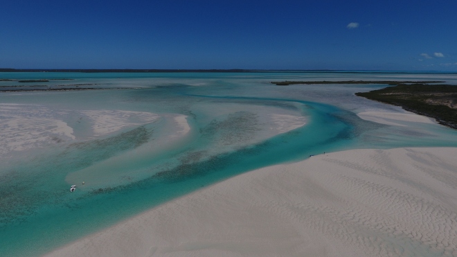
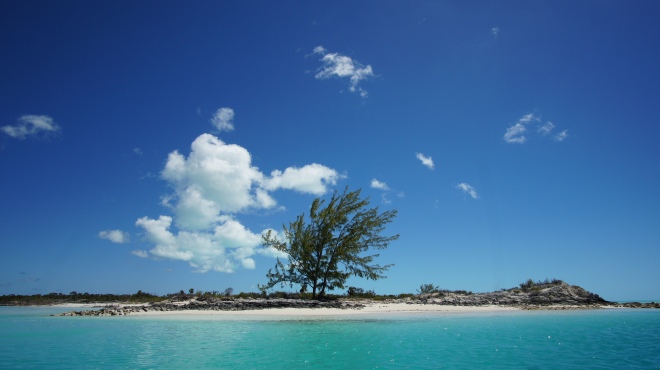
We’re drifting in the dinghy through Joe Sound. It’s nearly low tide and the white sands of the sound are exposed. Cutting through them are the turquoise waters on which we float. The tidal current is taking us back out towards the sea and overhead the sun is shining brightly. The vast sky is bright blue only broken up with the occasional fluffy white cloud.
We spot several dark shapes in the shallows and as we edge closer they become clearer, two stingrays and a baby nurse shark. There are a few birds circling above us and in the distance we can see some people stood knee deep in water on the flats bonefishing.
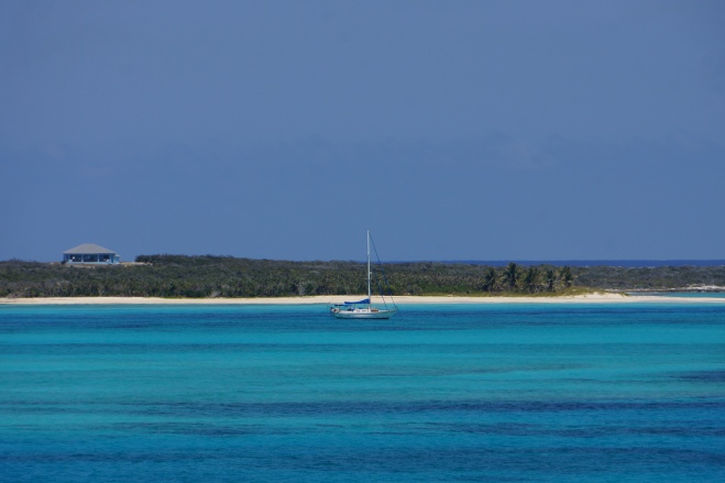
The opening into the sound from the ocean is narrow and reasonably shallow but a few boats have managed to squeeze in here to anchor. It seems some have been here a while. A dilapidated fishing boat has come to end of its life washed up onto one of the sand banks. It looks sad leaning over to one side, parts of it crumbling away. It’s a fairly common sight around the islands and always triggers my curiosity as to its story.
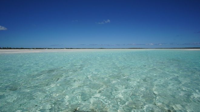
Walking along the edge of the sand banks the clear yet turquoise waters flow beside us, the sand itself is rippled as a result of the waters tidal movements. The water looks inviting, especially in this heat, but the current is made obvious by occasional floating leaves and twigs. As with many places in the Bahamas the current is strong and it’d be dangerous to go for a dip here.
We have a moment when we realise how fortunate we are to be here. Not only in the Bahamas, but right here at Joe Sound specifically. Had this location have been in closer proximity to the tourist trail it would not have the same feel. The raw beauty would still be here, but the experience would be very different.
It’s times like this when we’re off the beaten path we can really absorb our surroundings and appreciate the natural beauty. I guess that’s a major benefit gained from sailing the Bahamas, we really can escape from civilisation if we choose.
We’ve anchored in Calabash Bay in the north west of Long Island, the beach here stretches for what seems likes miles and it’s the perfect anchorage to explore Joe Sound from. Having spent a few days here exploring, repairing a tear in our sail and socialising with friends on sailing vessels Rat Catcher and Joda we find ourselves on the move again down towards Clarence Town. It’s located on the East coast so our route takes us around the northern tip of Long Island and then southeast along the coast for around 40 miles, crossing the Tropic of Cancer. We have to motor the whole way as the weather just isn’t playing ball, the wind’s coming straight out of the southeast. It’s not something we enjoy having to do but with time restraints and plenty more places to visit we need to get going.
We’re cautious entering Clarence Town harbour as there are breakers crashing on the nearby reef but we safely navigate our way through the swell and into the anchorage. There’s a surprising amount of protection from the southeast as a result of the surrounding reef, but we’ve heard the anchorage can get a bit hairy in northerly winds so as always we’ll keep a close eye on the forecast.
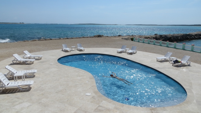
We’re excited to see what this end of Long Island has to offer as we’ve done no research prior to arriving here! We first stop off at Flying Fish Marina where we have the warmest of welcomes from Kevin the dock master. We’ve come over in the yacht to simply refill with fuel but Kevin makes us feel so welcome, he’s truly a credit to the marina. As a result we briefly stay at the marina to check out their facilities for future reference. Due to its location the marina mainly caters for sports fishing boats but sailboats are also welcome. I can highly recommend a dip in their freshwater pool overlooking the ocean and their restaurant also serves great food at reasonable prices.
Whilst we’re at the marina we meet a lovely couple, Craig and Silke, having a coffee at the marina bar. They’re here on holiday and are staying at a hotel just down the road. They’re intrigued by our adventure so we invite them aboard, show them around our ‘home’ and show them the ropes (literally) as we leave the fuel dock and head back out to the anchorage.
Later in the day Ben and I attempt to visit Dean’s Blue Hole four miles away by dinghy. We’ve heard that it’s the world’s second deepest ocean hole where the water suddenly plummets from ankle deep to 663 feet deep. We fail in our attempt to get there, the ocean swell is just too much and the narrow entrance into the bay in which the blue hole is located is surrounded by rocks.
By chance later on at the marina I bump into Craig and Silke, they have a hire car and kindly offer to drive us to the blue hole the next morning. As I leave the dock in the dinghy and start to head back out to the yacht I see a small sailboat entering the anchorage area. It catches my eye as it’s emblazoned with “Solo Atlantic Crossing”! The boats moving cautiously and I’m intrigued so I motor over in the dinghy to say hello and see if everything’s OK. Mike the captain is from Poland, he has no depth sounder on board and therefore doesn’t know if he’s going to go aground. Unfortunately I can’t help him with that aspect but I can help in another way. He has no dinghy and his only way to get ashore once he’s anchored is by swimming. I offer to swing by later on and drop him ashore to save him yet another salt water dip! Ben and I are heading for a meal at the marina and we invite him to join us. It turns out Mike is intending to sail the 16.5 foot sailboat across the Atlantic solo in just a few weeks time. He tells us the boat is definitely capable as his friend has already sailed it across the Atlantic to get it here. The boat has no refrigeration and not even a head (that’s a toilet to any landlubbers)! I can’t say his plans are something I aspire to but he has a great attitude towards his adventure and we have the utmost respect for him.
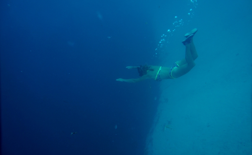
The next day all five of us cram into a compact rental car and head off to Dean’s Blue Hole. A bumpy gravel “road” leads us off the main highway and down to the coast. At first glance the bay looks like many others, clear water lapping against the white sand. But as we walk around to the left we see the water turns from light turquoise to a deep blue. It’s here that the underwater world drastically changes and we can’t resist the opportunity to snorkel this unique location despite the drop off ledge making us feel a little anxious. In the shallow water my stomach skims the sandy bottom as I snorkel but as I edge towards the hole it slopes away before vertically dropping into a dark abyss. Around the edge fish are visible and I watch a small Barracuda dart off at lightning speed in an attempt to catch a smaller fish. As another fish swims over the ledge and down into the hole it totally disappears from sight into the darkness. I have to stop my mind conjuring up images of mythical human-eating sea creatures lurking in the deep water beneath me.
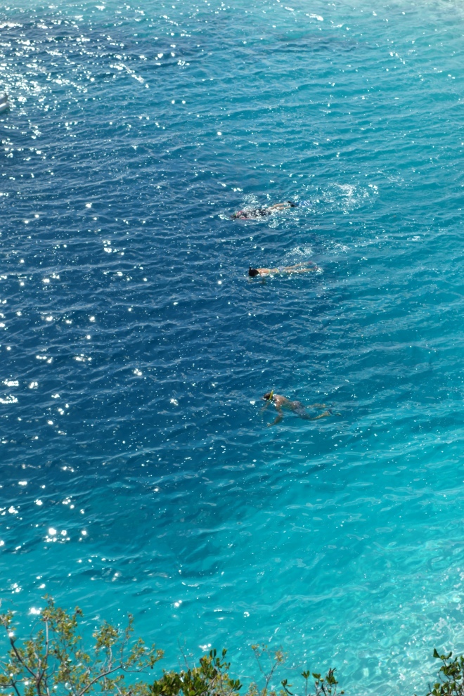

Just as we’re drying off from our snorkel world champion free divers turn up to use the location for training. They have a floating platform located in the middle of the hole where they carry out relaxation and breathing techniques prior to immersing themselves into the deepest darkest depths. The world record for a totally unassisted free dive is a staggering 102 metres, completed by William Trubridge who’s here training today.
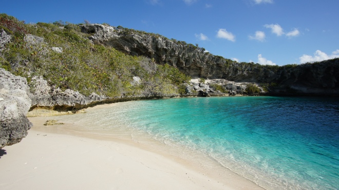
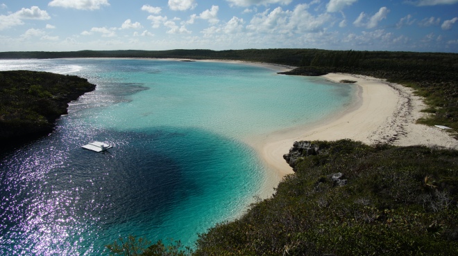
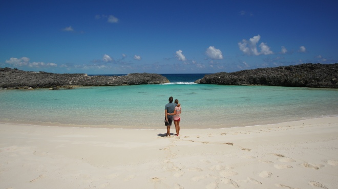
A short drive along the road is a stunning bay formed by the oceans deep water squeezing through a small gap in the rocks. Inside the bay the shallow, peaceful, bright blue water is edged by a crescent of soft white sand. It’s secluded and only accessible by walking over sand dunes from another nearby beach, as a result it’s perfectly deserted when we arrive.
From Clarence Town we next make the jump over to Crooked Island where we anchor up at French Wells Point. This is a remote location with Crooked Island having only 330 inhabitants, it’s no surprise to find we have the anchorage entirely to ourselves. We’re surrounded by clear waters, rugged coastline, small uninhabited islands and mangroves. It’s bliss, the silence is gorgeous and the only other boat we see here today is a passing local fisherman. This is what the Out Islands are all about.
A walk along the west facing beach the next day brings a huge smile to my face. As I walk alone I wonder when it was that this beach was last walked along. It certainly wasn’t today, in front of me the footprint free sand curves off into the distance. I feel free and can’t resist the urge to run along the beach, stopping now and again to twirl around in the sunshine with my arms in the air. I really hope no one else is here, I must look a little strange, or maybe just happy.
In the shallow waters I treat myself to one of my favourite beauty treatments. A full body exfoliation using local natural products…AKA a good all over scrub using handfuls of the powdery white sand followed by a salt water rinse.
Exfoliation complete I wander back along the beach, looking for washed up sea glass and pretty shells as I go. Back at French Wells Point the chalky coastline crumbles away into the turquoise waters creating a dramatic effect. Hoping to find some lobster here we snorkel but we have no luck.
A couple of days later we struggle to leave French Wells in our boat. On the way in here we established our charts are not accurate in regards to the depths at the entrance due to shifting sand. Visual piloting had proved successful for our entrance so we decide to follow our tracked route in from then, whilst also carefully observing the waters in front of us. We follow the deeper darker channel out but we’re now faced with a wall of light turquoise shallow water. The route we came in via is not an option, today it’s too shallow despite being at the same stage of tide. We seem to be stuck in here. We head to the right but it gets more and more shallow. The depth sounder shows just over 5 feet of water, our draft is 5 foot so I turn around but I don’t know which way to go next. With Ben on the bow he points towards another area to try. It looks shallow, but then again all of it does. We must be able to get out here somehow, but it’s going to be close.
As we attempt another route I watch the depth sounder again read worrying depths but we’re too late with our decision to turn around. With a bump the boat hits the seabed. The keel wedges into the sand so I quickly put the engine into reverse in an attempt to get us back off. Then with the wheel on full lock to the right and some forward power we slowly turn and start to edge our way back off the sand bank. The small waves make us bump along the sand but all of a sudden we’re off, albeit still in the shallow area we were trying to exit from. After another attempt at exiting the area we’re successful and I breathe a huge sigh of relief as I watch the depth sounder creep up…6ft, 7ft, 10ft and before we know it in less than a mile we’re in over a thousand feet of water.
After this nerve wracking start we continue on our longest journey to date, 100 nautical miles to Mayaguana which will be our final stop in the Bahamas. We’ve estimated the journey will take around 20 hours so we’re due to arrive shortly after sun rise tomorrow morning. We find we have to motor some stretches of our journey as the wind angle isn’t quite where we want it to be. But as we turn further south at the top of Acklins Island we hoist the sails and switch the engine off. This is what it’s all about, using the force of mother nature to propel us through the water and onto our destination.
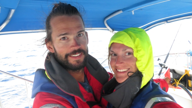
As the sun sets we begin our turns on watch at the helm. We’ve decided to do it in three hour stints each, one of us sleeping when the other is on watch.
It’s 4am and I’ve just started my last turn on watch. In between the odd cloud I can see stars twinkling and the moon is shining brightly casting some light on the ocean all around me. Sat at the helm with my feet up I’m struggling to stay awake, my eyelids keep involuntarily closing, I’m exhausted. The feeling is reminiscent of my times working night shifts, the thought of clambering into bed when this is over is so appealing. For now though I must stay awake, I check the chart and everything’s going well. Alan the Autopilot is behaving himself and we’re on track. As Ben sleeps in the cabin I’m kept company by a single crow-like bird who’s hitched a ride on our boat. We’re miles away from land so I can’t blame him.
When the sun begins to creep up over the horizon we’re both awake and we watch as the light fills the sky. We’re nearing Mayaguana and we’ve made good time, in fact we’re a little early so we reef the main to slow us down. We arrive at Abrahams Bay around 7.30am but the sun is not high enough in the sky for us to be able to safely navigate our way through the coral heads to the anchorage. A sailboat beached on the reef nearby is a stark reminder of how cautious we need to be here. We anchor just outside of the bay so we can get some much needed rest, we’ll move the boat around into the anchorage later in the day.
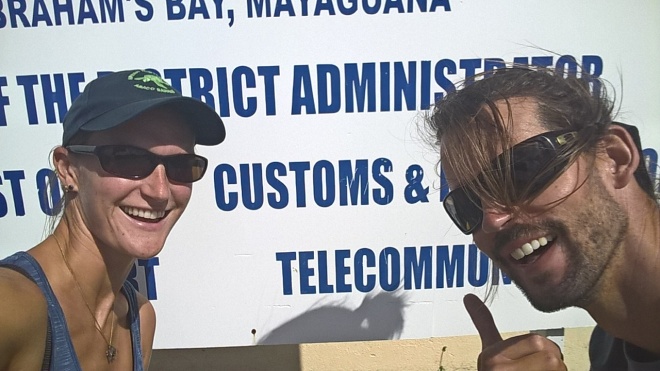
We spend a few days at Abrahams Bay whilst we wait for suitable weather to leave. There’s not much here at all, just a small settlement and a handful of residents. Due to it being the most easterly Bahamian island one facility they do have here is a customs and immigration office. We pop in one day to officially check ourselves out of the country, something we forgot to do when we left the USA three months ago.
The Bahamas have been the perfect destination for sailing, if not a little challenging at times. The memories of crystal clear waters, white sandy beaches, rugged coastline and small cays will last a lifetime time.
For now though with our passports stamped and the boats departure papers completed we’re ready to head for our next destination, the Turks and Caicos islands.
